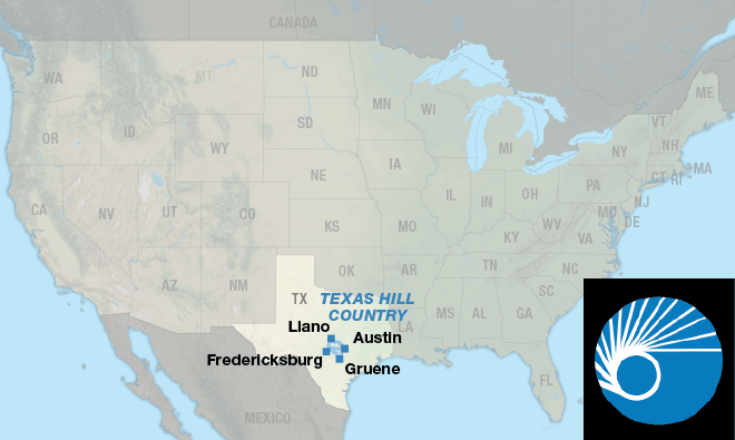
Texas Hill Country Loop
| Texas Hill Country Loop Austin, TX to Austin, TX 1 Map Set | GPX Data | Overview | Buy | Mobile App |
|---|---|
| 1. Austin, TX to Austin, TX | Detail |
Many sites to see.
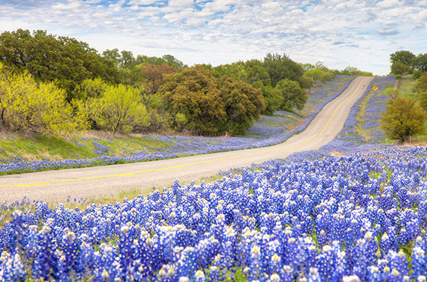
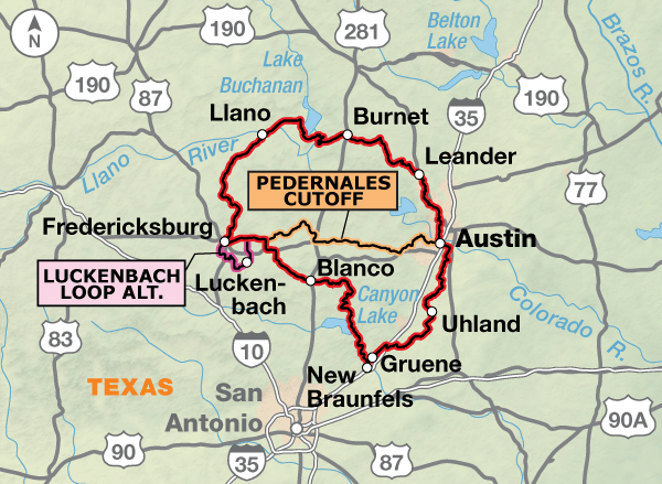
Bluebonnets and other wildflowers in the spring, historic sites, music, friendly towns, rivers and state parks all can be experienced when you cycle this route. The 316.9-mile loop begins and ends in Austin, and includes cutoff routing in case your tour is only for a long weekend.
The route begins in downtown Austin where there are many options for detours off the route. Some that you will be close to include the state capitol, Barton Springs, a local swimming hole, and Lady Bird Lake. Leaving downtown Austin you’ll cross Lady Bird Lake and head past McKinney Falls State Park.
Riding south from McKinney Falls State Park to Gruene you will encounter a network of mostly narrow, rural 2-lane county and state roads. Use caution on heavily trafficked FM 1102. The 1-mile stretch south of Hunter has no shoulder and can carry heavy truck traffic on weekdays.
While in Gruene, stop for a stroll through the quaint town that becomes a thriving tourist destination on weekends and throughout the summer. Gruene Hall, the oldest dance hall in Texas with daily music venues, is a huge tourism draw and you’ll be riding right past it.
After Gruene you will follow the Guadalupe River up to Canyon Lake Dam. From May through September this stretch can become quite busy with “toobing” traffic (the Guadalupe River is a river tubing mecca).
When you reach the Canyon Lake Dam, the real Texas Hill Country begins. Get ready for a lot of ups and downs, scenic roads and less traffic. When you reach Ranch Rd. 32 you might consider taking 5-mile total out and back detour east and ride up to Devil’s Backbone, a rest area overlooking the Blanco River valley with an almost 180 degree view of the hill country.
You’ll pass through Blanco and the river inside Blanco State Park is a great place to take a dip after a long ride.
Now you are on your way what many in Texas consider cycling Nirvana as you head to Gillespie County and Fredericksburg. Along the way you will pass the Lyndon B. Johnson (LBJ) State Park and Historic Site, which in the spring, from March through May, can be covered by blankets of wildflowers. Tours of the ranch are offered.
Fredericksburg is one of the most popular destinations in the hill country. On weekends there is usually something happening in Marketplatz, a plaza located in the center of the city. The 30.5-mile Luckenbach Loop Alternate can be done as a day ride. This destination is best known for the song Willie Nelson and Waylon Jennings coined about the town and it is a great place to hang your helmet and enjoy a cold beverage under one of the huge oak trees.
Heading toward Llano, the roadsides is often covered with wildflowers in the spring. You will then pass two of the Highland Lakes, Lake Buchanan and Inks Lake, as you ride toward Burnet. There are a couple of parks to stop at along the lakes for a break.
The route from Burnet follows lightly traveled county and state roads to the suburbs of Austin. Many of the roads you will ride on upon reaching Austin will be on established bike routes through quiet residential neighborhoods.
If your time in Texas is limited and you need to shorten your trip, you can take the 72.9-mile Pedernales Cutoff between Fredericksburg and Austin. This cutoff makes the northern loop 242.5 miles, and the southern loop 220.2 miles, just about 100 miles shorter than the larger loop.
Photo by Rob Greenbon
This route has it all – from flat to rolling to hilly terrain.
| Texas Hill Country Loop - Main Route | ||||
|---|---|---|---|---|
| Section | Distance | Elevation | Total Climb | Avg. Climb/mile |
| Total | 316.9 miles | Minimum: 405 ft.Maximum:2070 ft. | 14,070 ft. clockwise14,055 ft. counterclockwise | 44 ft. per mi. clockwise44 ft. per mi. counterclockwise |
| Texas Hill Country Loop Alternates | ||||
|---|---|---|---|---|
| Name | Section | Distance | Total Climb | Avg. Climb/mile |
| Pedernales Cutoff | 1 | 72.9 miles | 4,125 ft. east bound5,305 ft. west bound | 57 ft. per mi. east bound73 ft. per mi. west bound |
| Luckenbach Loop Alternate | 1 | 30.5 miles | 1,265 ft. clockwise1250 ft. counterclockwise | 41 ft. per mi. clockwise41 ft. per mi. counterclockwise |
RIDING CONDITIONS
The route begins in downtown Austin where there are many options for detours off the route. Some that you will be close to include the state capitol, Barton Springs Pool — a local swimming hole, and Lady Bird Lake. For potential routes to reach these locations, see the Austin City Bike Map at advcy.link/austinmap. Leaving downtown Austin you’ll cross Lady Bird Lake and head past McKinney Falls State Park.
Riding south from McKinney Falls State Park to Gruene you will encounter a network of mostly narrow, lightly trafficked, rural 2-lane county and state roads. Use caution on heavily trafficked FM 1102. The 1-mile stretch south of Hunter has no shoulder and can carry heavy truck traffic on weekdays. Watch for potholes as you approach the San Marcos River outside of Martindale. Flash floods have a tendency to wash roads away, and although it doesn’t often rain in Texas, when it does, it generally comes all at one time. Be prepared for flood-related road closures and detours on all parts of the route, especially when cycling during the wet season in late spring-early summer.
While in Gruene, stop for a stroll through the quaint town that becomes a thriving tourist destination on weekends and throughout the summer. Speed limits are the lowest you’ll encounter, but be on the alert for distracted drivers.
After Gruene you will follow the Guadalupe River up to Canyon Lake Dam on River Rd., a narrow 2-lane road. From May through September this stretch can become quite busy with “toobing” traffic (the Guadalupe River is a river tubing mecca) and it’s best to ride it early. The rest of the year the road can be ridden pleasurably any time of day.
When you reach the Canyon Lake Dam, the real “Texas Hill Country” begins. Get ready for a lot of ups and downs, scenic roads, and less traffic. When you reach Ranch Rd. 32 from FM 306 you might consider taking a 5-mile total out and back detour east and ride up to Devil’s Backbone, a rest area overlooking the Blanco River Valley with an almost 180 degree view of the hill country. Ride cautiously on the 0.6 mi. of RR 32 between Mail Route Rd. and FM 484. That section has no shoulder and can have heavy traffic.
Between Fischer and Blanco, you’ll travel through a remote area in the heart of “Texas Hill Country”, which is peppered with wineries and retreat/event centers. It travels around the Blanco River, which is loved for its clean, shallow waters with limestone riverbeds. Note that there are not many traditional services between Canyon Lake and Blanco. Plan lodging and food accordingly.
Passing through Blanco, cyclists enter what many Texans consider cycling Nirvana as you ride through Gillespie County and Fredericksburg. Fredericksburg is one of the most popular destinations in the hill country. On weekends there are usually events happening and it is advisable to make reservations in advance.
The 30.5-mile Luckenbach Loop Alternate can be done as a day ride. On weekends Luckenbach can be very busy, with many tourists riding in on motorcycles.
Heading toward Llano, the land alongside SR 2323 is often covered with wildflowers in the spring. Crossing the narrow steel cantilever bridge over the Llano River can be unnerving for some, but there is a pedestrian sidewalk on the east side of the bridge.
You will pass two of the Highland Lakes, Lake Buchanan and Inks Lake, as you ride toward Burnet. A large part of the ride around the lakes is on lightly traveled 2-lane roads with only a 4.4-mile section on the 4-lane portion of SR 29 that has more traffic. There are a couple of parks to stop at along the lakes for a break.
The route from Burnet follows lightly traveled county and state roads to the suburbs of Austin. The route through Leander and Cedar Park includes many turns, but is a delightful ride through quiet neighborhoods in an otherwise very busy area.
For those who wish to avoid the winding ride on the north side of Austin, the Capital MetroRail system is a convenient option to make your way downtown from either the Leander or Lakeline Stations. For more information see advcy.link/austinmetro. Upon reaching Austin, the route will be on established bike routes.
Long term parking is available at the Austin Bergstrom International Airport. Though not the most direct route, if you are riding from there, we recommend riding south on the bike path paralleling SR 71, then west on FM 973 then north on Burleson Rd. to join the route near McKinney Falls State Park.
If your time in Texas is limited and you need to shorten your trip, you can take the 72.9-mile Pedernales Cutoff between Fredericksburg and Austin. Riding the northern loop is 242.5 miles while the southern option clocks in at 220.2 miles. Traffic will mostly be light but fast moving. The terrain is rolling. North of Johnson City, U.S. 281 carries heavy traffic with little shoulder. Be cautious and ride defensively. Fitzhugh Rd. has been getting more traffic the last several years. Construction to add 4 ft. shoulders along the first 2 miles of the Fitzhugh Rd. (from U.S. 290) is scheduled for 2024.
All known Amtrak stations are listed on this map but not all stations provide bicycle service. Check if bicycle service is provided at both the starting and ending stations on your trip using the spreadsheet and other trip planning resources at advcy.link/amtrak.
CLIMATE
The eastern two-thirds of Texas has a humid, subtropical climate that is occasionally interrupted by intrusions of cold air from the north. Generally, annual precipitation decreases about an inch for each fifteen-mile displacement from east to west, with East Texas receiving about 44 inches of rain falling mostly in the month of May. With an average of sixty thunderstorm days a year, East Texas is most susceptible to severe localized phenomena like hail, high winds, and flash floods. On the other hand, winter is the driest time of the year in nearly all of Texas.
Updated: Mar 15, 2023
Route Highlights
Texas Hill Country Loop Highlights
- Austin, Texas
- Gruene Hall, Texas
- Lyndon B. Johnson State Park and Historic Site, Texas
- Fredericksburg, Texas
- Luckenbach, Texas
- Lake Buchanan, Texas
- Inks Lake, Texas
- Lyndon B. Johnson National Historical Park, Johnson City, Texas
- Lyndon B. Johnson Boyhood Home, Johnson City, Texas
More Route Resources
- Planning for the Texas Hill Country Loop [VIDEO]
- Austin Bicycle Maps
- Austin Capital MetroRail
- Barton Springs Pool, Austin
- Lady Bird Lake, Austin
- McKinney Falls State Park
- Blanco State Park
- Marketplatz, Fredericksburg
- Enchanted Rock State Park
- Pedernales Falls State Park
- Connect and share photos with other riders on Instagram: #acaTxHill
Updates to Recently Released Maps
If you are planning a bike tour, be sure to get the most recent map updates and corrections for your route by selecting the route, and the appropriate section(s), from the drop-down menu below.
Over time maps become less useful because things change. Every year Adventure Cycling’s Routes and Mapping Department create map updates and corrections for every map in the Adventure Cycling Route Network, which now totals 52,047 miles. With the help of touring cyclists like you, we receive updates on routing, services, camping, and contact information. Until we can reprint the map with the new information, we verify the suggested changes and publish corrections and updates here on our website.
PLEASE NOTE: Covid has been particularly hard on the small businesses along our routes. While we do our best to keep the maps and these online updates current, you may encounter more closed businesses and longer stretches with limited or no services.
Refer to these updates for the most current information we have and submit reports of changes to the Route Feedback Form for the cyclists coming after you.
NOTE: Map updates and corrections only pertain to long term changes and updates. For short term road closures, please see the Adventure Cycling’s Routes Temporary Road Closures discussion in our Forums.