Bicycle Route 66
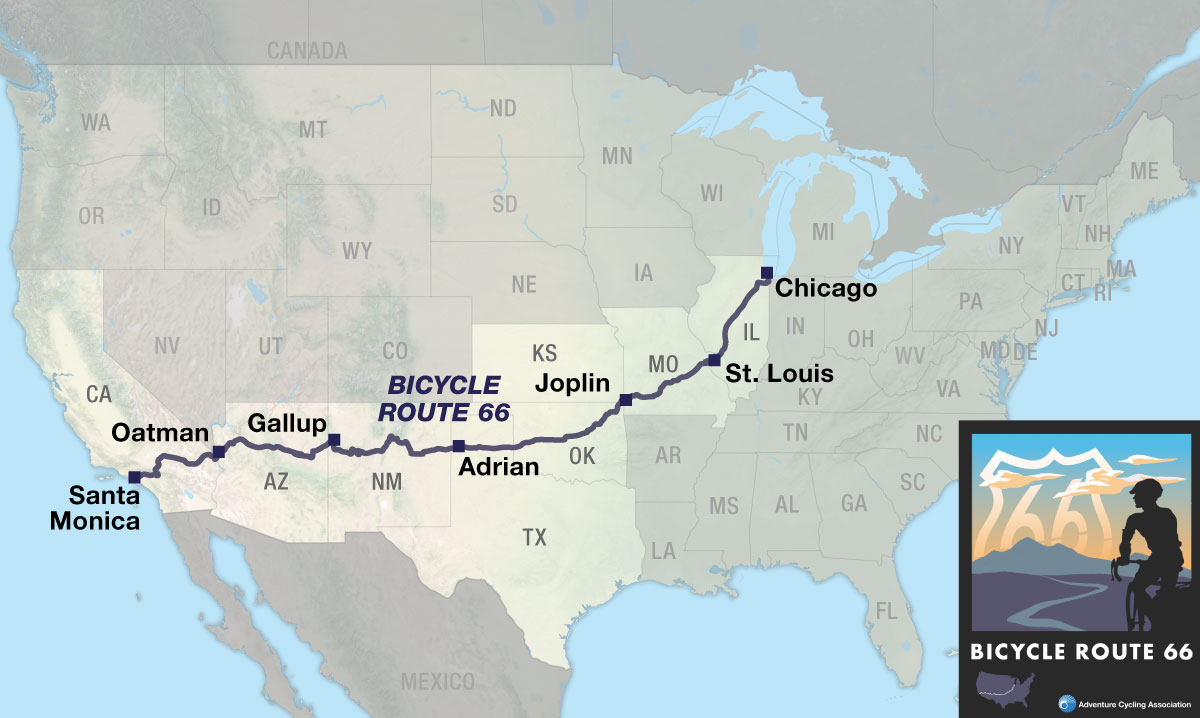
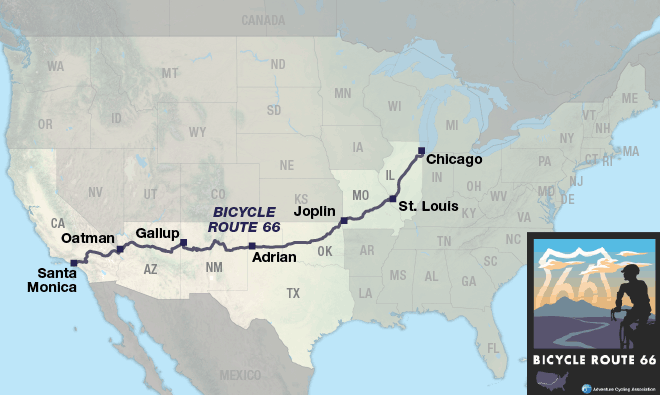
| Bicycle Route 66 Chicago, IL to Santa Monica, CA 6 Map Set | |
|---|---|
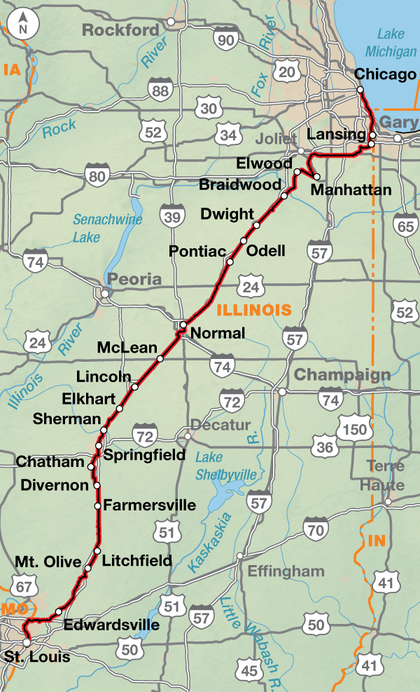
| 1. Chicago, IL to St. Louis, MO | Detail |
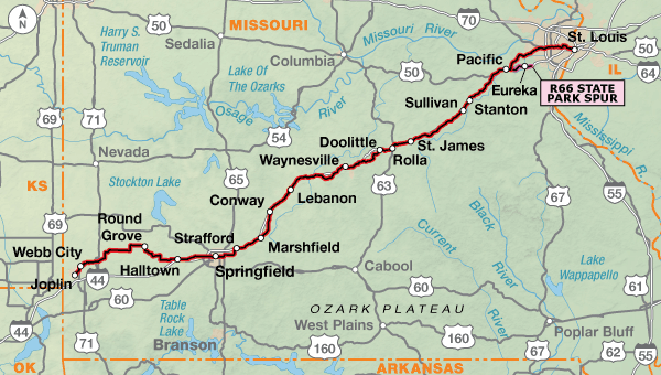
| 2. St. Louis, MO to Joplin, MO | Detail |
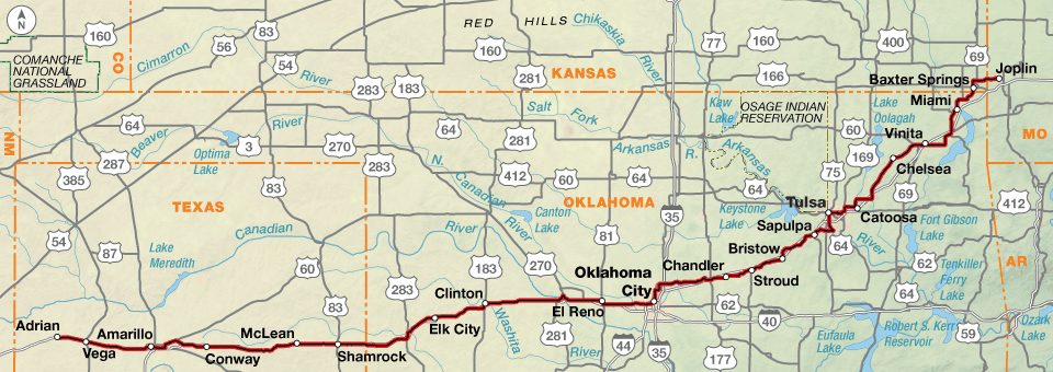
| 3. Joplin, MO to Adrian, TX | Detail |
| 4. Adrian, TX to Gallup, NM | Detail |
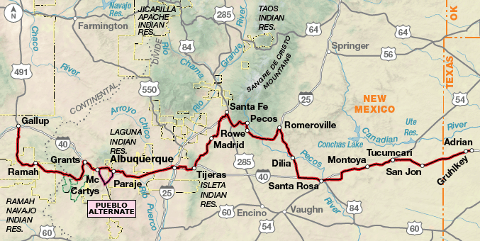
| 5. Gallup, NM to Oatman, AZ | Detail |
| 6. Oatman, AZ to Santa Monica, CA | Detail |
Biking for Your Kicks on Bicycle Route 66
For over 50 years, motorists traveled the legendary U.S. Route 66 – popularly known as Route 66 or The Mother Road – from Chicago, Illinois to the Santa Monica Pier in Los Angeles, California. Now it’s the cyclists’ turn.
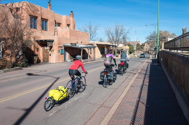
In view of the strong association between the historic roadway and America’s love affair with the automobile, it is perhaps ironic that hundreds of travelers will now attain independence from the motor vehicle by traveling Bicycle Route 66 under their own steam. While the cafes and grocery stores along the way remain important fuel stops for them, traveling cyclists can enjoy a certain satisfaction as they whiz past the many gas stations found in the towns and cities they visit.
Over the years Route 66 was in service there were multiple alignments of its path. Some of them exist today as Historic Route 66 and are signed in various ways. In many places Historic Route 66 was replaced by interstate highways. Bicycle Route 66 travels west on bike paths, county roads, and state, federal, and interstate highways. However, please note Bicycle Route 66 does not always follow Historic Route 66. Deviations were made based on present-day conditions.
Right from the start in Chicago, Illinois, Bicycle Route 66 diverges from Historic Route 66 due to heavy traffic conditions. The official start location on Lake Michigan in Grant Park at Buckingham Fountain allows the use of multiple bike paths and trails along with city streets out of the congestion to meet up with Historic Route 66 in Elwood. A short distance later, the route begins its parallel path with I-55 passing through the capital city of Springfield as well as many smaller communities.
Much of the route in Illinois is characterized by the prairie landscape and rolling hills. In Madison County, the route takes advantage of a number of county-maintained trails to the Mississippi River crossing on the historic Chain of Rocks Bridge into St. Louis, Missouri.
The Riverfront Trail leads cyclists into the city and past the Gateway Arch commemorating the launch of the Lewis & Clark Corps of Discovery Expedition. Once through the suburbs on city and county roads, Bicycle Route 66 begins paralleling I-44 mostly on frontage roads and some county highways. Not far out of St. Louis, cyclists will encounter the rolling hills of the northern reaches of the Ozark Mountains. West of Springfield, Missouri, the route leaves Historic 66 in favor of quieter county roads and state highways. Bicycle Route 66 rejoins Historic Route 66 east of Joplin.
Kansas contains only about a dozen miles of Route 66, the least of any of the eight states the highway runs through. That didn’t prevent the residents of the area from taking great pride in “owning” part of the highway.
Once the route reaches the Oklahoma border, the flat to rolling landscape will encompass a variety of different prairie types until it reaches the Great Plains of the Texas panhandle. In general, the terrain across Oklahoma is a gradual uphill again paralleling interstates, first I-44, then I-40.
Amarillo, Texas is the last large city on the route before you reach the midpoint of Historic Route 66 in Adrian, Texas. Up to this point in the route, services of most types are regularly available and there are no extended sections of sparse services. However, the availability of bike shops decreases as the route heads west.
Much of Bicycle Route 66 across New Mexico is either on or roughly paralleling I-40 and/or I-25. One notable exception is where the route heads north to Santa Fe following an older alignment of Historic Route 66 before returning south to Albuquerque. Cyclists wishing a more direct route can opt to ride the shoulder of I-40 to Tijeras then return to the route. A second exception takes cyclists onto the Turquoise Trail/State Highway 14 between Santa Fe and Tijeras providing beautiful open vistas before returning to Historic Route 66.
West of Albuquerque to Chambers, Arizona and again past Flagstaff, Arizona, Bicycle Route 66 passes through several Native American lands known as Pueblos, Nations, and Reservations. These are sovereign lands with their own cultural flavor. Etiquette across them will require you to be a bit more circumspect in your behavior. Stealth camping is not permitted and in most, permission must be granted to photograph or otherwise record the scenery and sites. While most of the roads through these lands are state owned, those on the Pueblo Alternate through Acoma Pueblo are not and are subject to closures periodically. A visit to the Sky City Cultural Center and Haak’u Museum is a must if riding this 27.1 mile alternate.
Just west of Grants, New Mexico, cyclists will cross the Continental Divide as they pedal through the El Malpais National Monument. For a more direct route between Grants and Gallup, you can choose to follow I-40 and its frontage roads. This is the original alignment of Route 66.
Gallup, New Mexico is home to the Brickyard Bike Park, which celebrated its grand opening in September 2013, with cycling celebrity Levi Leipheimer officiating. The bike park, coupled with a 15-year-long effort to build trails outside of town and recast the city as a mountain-biking mecca, has earned Gallup a formal designation by the state legislature as the Adventure Capital of New Mexico. Today, the area boasts two major networks of professionally designed, curvy singletrack trails, including the flagship High Desert Trail. Gallup hosts more mountain bike races than any other community in New Mexico and the High Desert Trail system has been designated a National Recreation Trail.
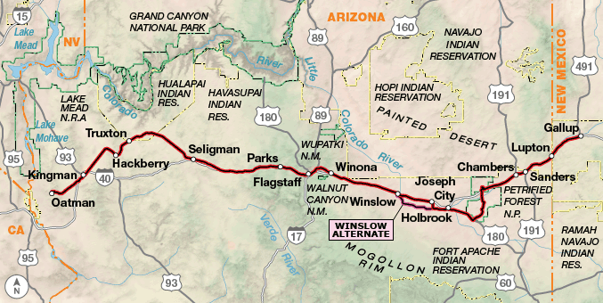
Bicycle Route 66 breaks from following Historic Route 66 to head south through the Petrified Forest National Park. Its hauntingly beautiful archaeological sites and unique geological formations include, not surprisingly, petrified trees.
In Flagstaff, Arizona you’ll see your first bike shop since Albuquerque. From Flagstaff, cyclists will ride a combination of I-40, paralleling service roads and county roads to Ash Fork before riding onto Old Route 66 the rest of the way across Arizona. From five miles south of Kingman to Topock at the California border, Old Route 66 has been designated by the Bureau of Land Management as the Historic Route 66 National Back Country Byway. It crosses Sitgreaves Pass in the rugged Black Mountains, where the BLM warns: “Travelers are advised that the portion of the highway passing through the mountains is a very narrow two-lane with no shoulders, extremely tight switchbacks, and many steep drop-offs.”
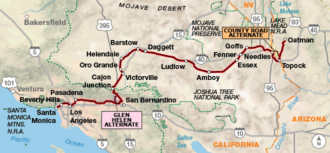
The entry into California drops cyclists into a long, desert stretch with very limited services from Needles to Barstow. This region is subject to violent thunderstorms and downpours in the summer monsoon and winter storm seasons. The weather pattern can result in flash flooding that closes the former Route 66 now known as the National Trails Highway (NTH) and thus Bicycle Route 66. Over the years the NTH has fallen into some disrepair and, in September 2014, a particularly bad storm system came through not only flooding the area but further damaging the NTH and several of the original Route 66 bridges causing long term closures of the road. However, there are long-term construction projects aimed at restoring the damaged portions. See advcy.link/sbtempclosures for road closures or inquire locally about conditions.
I-40 was built to replace the NTH. It is now the main thoroughfare between these two towns, and thankfully, has a well-maintained riding surface. While interstate riding is not our preference, it is the best solution to the problem of travel between Needles and Barstow if the NTH is impassable. Though I-40 is normally closed to bicycling, Adventure Cycling has worked with the California Department of Transportation (Caltrans) to come to an agreement about temporarily allowing cyclists to ride sections of I-40 to continue on Bicycle Route 66. (See the map updates and corrections for Bicycle Route 66, Section 6 for current detour information.)
Once out of the desert, services improve and traffic increases as the route becomes urban through the suburbs of Los Angeles. While there are several plaques in the area denoting the end of Historic Route 66, the terminus of Bicycle Route 66 is on the Santa Monica Pier at the sign located where the road meets the pier.
Photo by Michael Clark
This route contains a diversity of landscapes from the flat prairie grasslands of Illinois to the rolling hills of the northern reaches of the Ozark Mountains to the vast, open desert spreads across the southwest.
While there aren’t a lot of mountain passes on this route, across New Mexico, Arizona, and California there are long stretches across the desert with few services and significant heat depending on the time of year.
| Bicycle Route 66 - Main Route | ||||
|---|---|---|---|---|
| Section | Distance | Elevation | Total Climb | Avg. Climb/mile |
| Total | 2517.6 miles | Minimum: 0 ft.Maximum:7900 ft. | 88990 ft. west bound89500 ft. east bound | 35 ft. per mi. west bound36 ft. per mi. east bound |
| 1 | 339.9 miles | Minimum: 400 ft.Maximum:850 ft. | 4480 ft. west bound4665 ft. east bound | 13 ft. per mi. west bound14 ft. per mi. east bound |
| 2 | 326.3 miles | Minimum: 415 ft.Maximum:1510 ft. | 16415 ft. west bound15765 ft. east bound | 50 ft. per mi. west bound48 ft. per mi. east bound |
| 3 | 582.9 miles | Minimum: 535 ft.Maximum:4090 ft. | 19440 ft. west bound16550 ft. east bound | 33 ft. per mi. west bound28 ft. per mi. east bound |
| 4 | 504.6 miles | Minimum: 3765 ft.Maximum:7900 ft. | 23590 ft. west bound21220 ft. east bound | 47 ft. per mi. west bound42 ft. per mi. east bound |
| 5 | 404.5 miles | Minimum: 2260 ft.Maximum:7335 ft. | 13200 ft. west bound16955 ft. east bound | 33 ft. per mi. west bound42 ft. per mi. east bound |
| 6 | 359.4 miles | Minimum: 0 ft.Maximum:4290 ft. | 11865 ft. west bound14345 ft. east bound | 33 ft. per mi. west bound40 ft. per mi. east bound |
| Bicycle Route 66 Alternates | ||||
|---|---|---|---|---|
| Name | Section | Distance | Total Climb | Avg. Climb/mi |
| Route 66 State Park | 2 | 9.8 miles | 250 ft. east bound265 ft. west bound | 26 ft. per mi. east bound27 ft. per mi. west bound |
| Pueblo Alternate | 4 | 27.1 miles | 1120 ft. west bound850 ft. east bound | 41 ft. per mi. west bound31 ft. per mi. east bound |
| Winslow Alternate | 5 | 26.7 miles | 650 ft. north bound955 ft. north bound | 24 ft. per mi. north bound36 ft. per mi. north bound |
| County Road Alternate | 6 | 12.5 miles | 205 ft. north bound330 ft. north bound | 16 ft. per mi. north bound26 ft. per mi. north bound |
| Glen Helen Alternate | 6 | 9.6 miles | 210 ft. west bound955 ft. east bound | 22 ft. per mi. west bound99 ft. per mi. east bound |
For westbound riders this route is best ridden in spring with a departure in mid-April. This will allow most cyclists to make it through the highest humidities of the midwest and high heats of the desert before June through August. If departing in autumn, mid-August to September should allow cyclists to clear the mountains before heavy snows fall as well as avoid the heat and humidity. For eastbound riders starting in California, the best departure time is September.
Though the famous Route 66 song may indicate that you’d want to travel from Chicago to LA, based on general wind patterns, you’ll find them more in your favor if you ride eastbound, from Los Angeles to Chicago. Strong winds come from the west, southwest, and south during the riding season. The farther east you ride the winds come from the south, so about the time you begin angling to the northeast near Oklahoma City, the winds will be typically from the south-southwest.
While much of the route has plenty of food sources, riders should be prepared to carry food and water across some of the longer desert stretches in the Southwestern U.S. There are few bike shops from Amarillo, Texas until the outskirts of Los Angeles.
Some campgrounds will charge a cyclist traveling alone less if they have hiker/biker sites, but often they will charge the price of a regular tent or RV site, and that can easily be $10-$20/night. If you’re friendly and ask around, you can often get yourself invited to camp in a yard. In national forests you are allowed to camp anywhere on national forest land as long as you “pack it in, pack it out.” Many city parks are free to camp in.
You may also wish to sign up with Warmshowers, a reciprocal hospitality site for bicycle travelers, for other overnight options.
Route Highlights
- Midewin National Tallgrass Prairie, Section 1
- Lincoln Home National Memorial, Section 1
- Chain of Rocks Bridge, Section 1
- St. Louis, Missouri, Sections 1 and 2
- Meremac State Park, Section 2
- Route 66 State Park, Section 2
- Ozark Mountains, Section 2
- Ribbon Road, Section 3
- Hometown of Mickey Mantle, Commerce, Oklahoma, Section 3
- Hometown of Will Rogers, Claremore, Oklahoma, Section 3
- The Blue Whale of Catoosa, Section 3
- Slug Bug Ranch and Cadillac Ranch, Section 3
- Glenrio, Texas, Section 4
- Pecos National Historical Park, Section 4
- Turquoise Trail, Section 4
- El Malpais National Monument, Section 4
- Navajo Nation, Sections 4 and 5
- Petrified Forest, Section 5
- Painted Desert, Section 5
- Hualapai Native American Reservation, Section 5
- Mojave National Preserve, Section 6
- Mojave Desert, Section 6
- San Gabriel Mountains, Section 6
More Route Resources
- U.S. Bicycle Route System
- How to Travel with your Bike on Amtrak
- EZ 66 Guide for Travelers by Jerry McClanahan (all states)
- National Park Service Route 66
- No-Turn-Away Bike Camping Policies
- U.S. Bicycle Route 37 (Illinois)
- Chicago and Illinois bike maps
- Old Plank Road Trail (Illinois)
- Midewin National Tallgrass Prairie (Illinois)
- Madison County trail map (Illinois)
- U.S. Bicycle Route 66 (Missouri)
- St. Louis area greenway map (Missouri)
- St. Louis city bike maps (Missouri)
- Route 66 State Park (Missouri)
- Springfield bike map (Missouri)
- U.S. Bicycle Route 66 (Kansas)
- Tulsa RiverParks trails (Oklahoma)
- Tulsa regional trails (Oklahoma)
- Rte. 66 Trail (Oklahoma)
- Oklahoma City trails map (Oklahoma)
- Amarillo bike map (Texas)
- Santa Fe bike map (New Mexico)
- Albuquerque bike map (New Mexico)
- Railrunner train between Santa Fe and Albuquerque (New Mexico)
- Laguna Pueblo (New Mexico)
- Acoma Pueblo (New Mexico)
- Zuni Pueblo (New Mexico)
- Navajo Nation (Arizona)
- Discover Navajo (Arizona)
- Painted Desert Visitor Center (Arizona)
- Flagstaff bike map (Arizona)
- Mohave County road closure status (Twitter account) (Arizona)
- Fort Mojave Indian Tribe (Arizona)
- San Bernardino County road closure status (California)
- “Forgotten Road,” Ludlow to Newberry Springs alternate (California)
- Los Angeles area bike maps (California)
- Los Angeles bike maps (California)
- Connect and share photos with other riders on Instagram: #acaBR66
Updates to Recently Released Maps
If you are planning a bike tour, be sure to get the most recent map updates and corrections for your route by selecting the route, and the appropriate section(s), from the drop-down menu below.
Over time maps become less useful because things change. Every year Adventure Cycling’s Routes and Mapping Department create map updates and corrections for every map in the Adventure Cycling Route Network, which now totals 52,047 miles. With the help of touring cyclists like you, we receive updates on routing, services, camping, and contact information. Until we can reprint the map with the new information, we verify the suggested changes and publish corrections and updates here on our website.
PLEASE NOTE: Covid has been particularly hard on the small businesses along our routes. While we do our best to keep the maps and these online updates current, you may encounter more closed businesses and longer stretches with limited or no services.
Refer to these updates for the most current information we have and submit reports of changes to the Route Feedback Form for the cyclists coming after you.
NOTE: Map updates and corrections only pertain to long term changes and updates. For short term road closures, please see the Adventure Cycling’s Routes Temporary Road Closures discussion in our Forums.
