Southern Tier
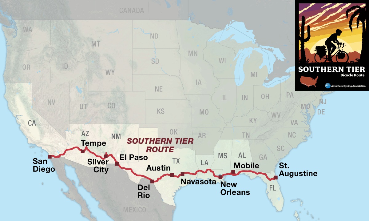
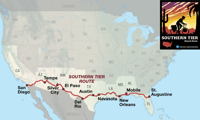
| Southern Tier San Diego, CA to St. Augustine, FL 7 Map Set | |
|---|---|
| 1. San Diego, CA to Tempe, AZ | Detail |
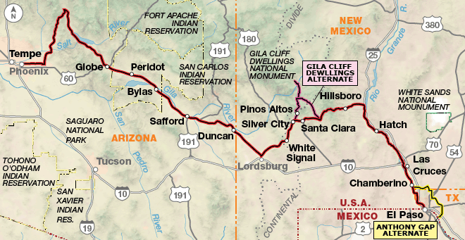
| 2. Tempe, AZ to El Paso, TX | Detail |
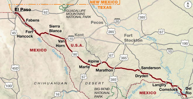
| 3. El Paso, TX to Del Rio, TX | Detail |
| 4. Del Rio, TX to Navasota, TX | Detail |
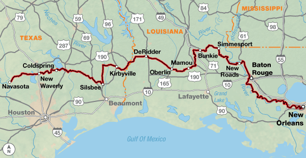
| 5. Navasota, TX to New Orleans, LA | Detail |
| 6. New Orleans, LA to DeFuniak Springs, FL | Detail |
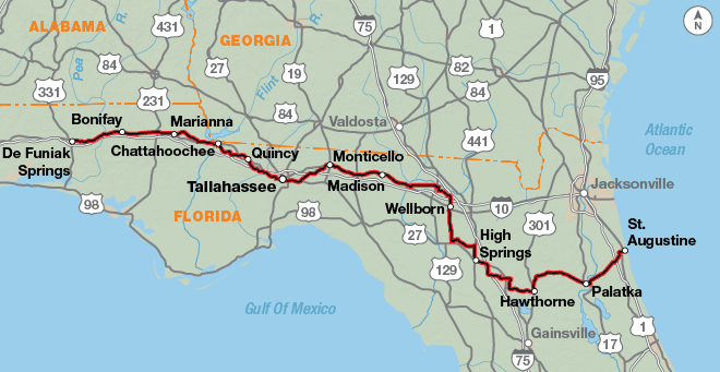
| 7. DeFuniak Springs, FL to St. Augustine, FL | Detail |
Experience fascinating landscapes, fabulous food, and diverse cultures.
The Southern Tier Bicycle Route is our shortest cross-country route and offers a wide variety of terrain, vegetation, climate, and people all the way across the nation from the Pacific to the Atlantic. The route is rich in human culture and history — ranging from the Spanish and Mexican influences in California, to the ancient indigenous pueblo cultures in Arizona and New Mexico, to the imprint of the Spanish conquistadors in Texas, to the bayous and French influences of Louisiana, to the Old South of Mississippi and Alabama, to a four-hundred-year-old city in Florida.

After climbing east from San Diego and topping out at 3,890 feet at the Tecate Divide, you’ll enter desert country. The route travels through the Yuha Desert and the below-sea-level, irrigated Imperial Valley. In Arizona, snowbirds abound as the route travels through Phoenix and its surrounding communities. The Besh Ba Gowah Archeological Park in Globe, though off route, is very interesting. You’ll be riding through dry, sparsely populated ranch country where every town will be a welcome sight. Don’t pass up the chance to top off your water bottles. New Mexico offers Silver City for the latte drinkers, along with the Gila Cliff Dwellings National Monument (on the Gila Cliff Dwellings Alternate), which are some of the best preserved Mogollon cliff dwellings around.
The ride along the Rio Grande into El Paso, Texas, is a treat for bird lovers, especially during migration season, when birds are flying north or south. Texas dominates this route, taking up an entire third of the mileage. Starting in El Paso, just across the Rio Grande River from Juarez, Mexico, the route follows the river southward before turning east. Marfa, a small desert town in west Texas, is known as an arts hub. Southeast of town, there is a viewing platform from which the mysterious orbs known as the “Marfa Lights” phenomenon can sometimes be seen. After Alpine, towns are few and the country desolate, full of sagebrush and tumbling tumbleweeds. As you travel through central Texas, the terrain starts to feel like the Alps, but this is actually the famous “hill country.” This diverse area serves some great barbeque. In Austin, make sure you go hear some of the diverse music available at the nightclubs on Sixth Street.
Louisiana is like no other state in the United States due to its history, language, culture, and food. First of all, they have parishes instead of counties, due to early white settlers being Roman Catholic under French and Spanish rule. Boundaries generally coincided with church parishes when the U.S. bought the Louisiana Purchase in 1803. Traveling right through the middle of Cajun country, in places like Mamou, a stop in a cafe is a trip unto itself. The crowd is speaking English, but you can’t understand the words. New Orleans is a highlight of the route, famous for its distinctive music scene, Creole food, unique dialects, and many festivals and celebrations. Try to hear some lively Cajun music if you have the time. Mississippi offers some beachfront riding into Alabama, where the route crosses a bridge to Dauphin Island. From there it’s a ferry ride across Mobile Bay to Gulf Shores, and some of the whitest beaches in the world. If the ferry is closed due to inclement weather, you will have to take the alternate route through Mobile.
The scenery varies greatly across Florida, from the historic coastal city of Pensacola to the alligator-filled waters in the area around Palatka. The route ends in St. Augustine, a city full of interesting buildings, and the Castillo de San Marcos, a fort that has guarded the city’s waterfront for over four centuries.
Photo by Dennis Coello
The Southern Tier route offers challenging terrain right from the start, with some longer climbs leaving San Diego all the way up to the Tecate Divide, about 72 miles east of the Pacific Ocean. There are two mountain passes in New Mexico, the highest being Emory Pass at 8,228 feet, which is also the route’s highest point. The Gila Cliff Dwelling Alternate, just north of Silver City, New Mexico, goes to the Gila Cliff Dwellings National Monument and offers some steep, challenging, rolling climbs and descents, as does the hill country west of Austin, Texas. East of Austin the route flattens out as it meanders through piney woods, by bayous, along farmlands and woodlots, and past the Gulf Coast all the way to the Atlantic Ocean.
| Southern Tier - Main Route | ||||
|---|---|---|---|---|
| Section | Distance | Elevation | Total Climb | Avg. Climb/mile |
| Total | 3078.4 miles | Minimum: -155 ft. Maximum:8,185 ft. |
101,730 ft. east bound 102,490 ft. west bound |
33 ft. per mi. east bound 33 ft. per mi. west bound |
| 1 | 432.4 miles | Minimum: -155 ft. Maximum:4,120 ft. |
17,125 ft. east bound 16,015 ft. west bound |
40 ft. per mi. east bound 37 ft. per mi. west bound |
| 2 | 512.9 miles | Minimum: 1,155 ft. Maximum:8,185 ft. |
31,600 ft. east bound 29,540 ft. west bound |
62 ft. per mi. east bound 58 ft. per mi. west bound |
| 3 | 432.6 miles | Minimum: 975 ft. Maximum:5,115 ft. |
10,580 ft. east bound 13,360 ft. west bound |
24 ft. per mi. east bound 31 ft. per mi. west bound |
| 4 | 433.0 miles | Minimum: 150 ft. Maximum:2,385 ft. |
20,665 ft. east bound 21,425 ft. west bound |
48 ft. per mi. east bound 49 ft. per mi. west bound |
| 5 | 570.4 miles | Minimum: 0 ft. Maximum:435 ft. |
8,545 ft. east bound 8,855 ft. west bound |
15 ft. per mi. east bound 16 ft. per mi. west bound |
| 6 | 306.2 miles | Minimum: 0 ft. Maximum:300 ft. |
4,210 ft. east bound 4015 ft. west bound |
14 ft. per mi. east bound 13 ft. per mi. west bound |
| 7 | 390.9 miles | Minimum: 0 ft. Maximum:295 ft. |
9,005 ft. east bound 9,280 ft. west bound |
23 ft. per mi. east bound 24 ft. per mi. west bound |
| Southern Tier Alternates | ||||
|---|---|---|---|---|
| Name | Section | Distance | Total Climb | Avg. Climb/mile |
| Gila Cliff Dwellings Alternate | 2 | 91.3 miles | 8,690 ft. east bound 8,905 ft. west bound |
95 ft. per mi. east bound 98 ft. per mi. west bound |
| Anthony Gap Alternate | 2 | 45.5 miles | 1100 ft. east bound 1,235 ft. west bound |
24 ft. per mi. east bound 27 ft. per mi. west bound |
| Mobile Bay Alternate | 6 | 92.3 miles | 2,195 ft. east bound 2260 ft. west bound |
24 ft. per mi. east bound 24 ft. per mi. west bound |
The Southern Tier Route is best ridden in early fall or spring (typically mid-September to October or March to April). In September and May, there still might be some very hot weather to contend with at either end of the route. See our blog post When to Ride: Southern Tier for more information on timing. Note that snow can occur at any time in the higher elevations in the Southwest during the winter, and the highest pass in New Mexico is over 8,000 feet. If you are doing a winter trip, remember that you will have short daylight hours. Due to changing local conditions, it is difficult to predict any major wind patterns, but here are a few known observations. In California, dry easterly winds predominate in the fall, blowing west from the desert. In western Texas, winds from the Gulf of Mexico will cause headwinds for eastbound riders. Be aware that hurricanes can occur from June 1 through November 30 along the Gulf Coast of the Florida panhandle and can also hit the Atlantic seaboard.
Isolated stretches, especially in the western states of California, Arizona, New Mexico, and Texas are not uncommon. Services are infrequent and can dictate long miles on some days. The 273-mile stretch from Van Horn to Comstock, Texas, calls for specific planning and carrying of food and water. Bike shops are not as plentiful as one would like, and you might have to go off route to find them.
Some campgrounds will charge a cyclist traveling alone less if they have hiker/biker sites, but often they will charge the price of a regular tent or RV site, and that can easily be $10-$30/night. The maps list churches that have opened their doors to cyclists, but they aren’t all that closely spaced. If you’re friendly and ask around, you can often get yourself invited to camp in a yard. Our routes sometimes go through national forests (moreso in the west) and you are allowed to camp anywhere on national forest land as long as you “pack it in, pack it out.” Many city parks are free to camp in.
You may also wish to sign up with Warmshowers, a reciprocal hospitality site for bicycle travelers, for other overnight options.
Route Highlights
Southern Tier Highlights
- Anza Borrego Desert State Park, Section 1
- Cibola National Wildlife Refuge, Section 1
- Tonto National Monument, Section 2
- Besh Ba Gowah Archeological Park, Section 2
- Gila Cliff Dwellings National Monument, Gila Cliff Dwellings Alternate, Section 2
- La Mesilla Historic District, a National Historic Landmark, Mesilla, New Mexico, Section 2
- Rio Grande, Section 3
- Chamizal National Memorial, Section 3
- Amistad National Recreation Area, Section 3
- Texas Hill Country, Section 4
- Pedernales Falls State Park, Section 4
- Mamou, Louisiana, “The Cajun Music Capital of the World.” Section 5
- New Orleans, Louisiana, Sections 5 & 6
- Fort Gaines and Fort Morgan Historic Sites, Section 6
- USS ALABAMA Battleship Memorial Park, Mobile Bay Alternate, Section 6
- Pensacola, Florida, Section 6
- Florida Caverns State Park, Section 7
- St. Augustine, Florida, oldest continuously occupied European-established city and port in the continental U.S., Section 7
More Route Resources
- U.S. Bicycle Route System
- How to Travel with your Bike on Amtrak
- How to Deal with Dog Encounters
- San Diego Regional bike maps (California)
- U.S. Bicycle Route 90 (Arizona)
- Arizona DOT bike maps
- Phoenix Bicycling Maps (Arizona)
- Texas DOT state maps
- Big Bend Open Road Race Schedule (Texas)
- Austin bike map (Texas)
- Route options from Baton Rouge to New Orleans (Louisiana)
- Mississippi River Levee construction updates (Louisiana)
- Mobile Bay Ferry (Alabama)
- Gulf State Park Backcountry Trail (Alabama)
- U.S. Bicycle Route 90 (Florida)
- Tallahassee bike map (Florida)
- St. Marks Historic Railroad State Trail (Florida)
- Gainesville-Hawthorne State Trail (Florida)
- Palatka To Lake Butler State Trail (Florida)
- Palatka To St. Augustine State Trail (Florida)
- Connect and share photos with other riders on Instagram: #acaSoTier
Updates to Recently Released Maps
If you are planning a bike tour, be sure to get the most recent map updates and corrections for your route by selecting the route, and the appropriate section(s), from the drop-down menu below.
Over time maps become less useful because things change. Every year Adventure Cycling’s Routes and Mapping Department create map updates and corrections for every map in the Adventure Cycling Route Network, which now totals 52,047 miles. With the help of touring cyclists like you, we receive updates on routing, services, camping, and contact information. Until we can reprint the map with the new information, we verify the suggested changes and publish corrections and updates here on our website.
PLEASE NOTE: Covid has been particularly hard on the small businesses along our routes. While we do our best to keep the maps and these online updates current, you may encounter more closed businesses and longer stretches with limited or no services.
Refer to these updates for the most current information we have and submit reports of changes to the Route Feedback Form for the cyclists coming after you.
NOTE: Map updates and corrections only pertain to long term changes and updates. For short term road closures, please see the Adventure Cycling’s Routes Temporary Road Closures discussion in our Forums.
