Experience spectacular parks in the United States and Canada.
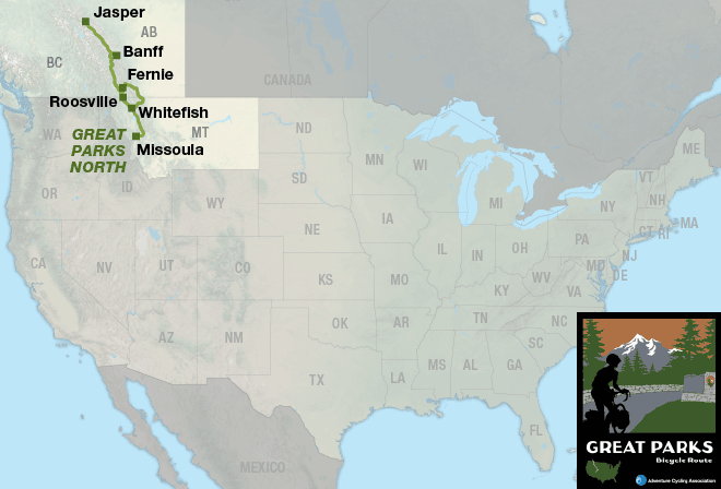
These two separate routes traverse the Rocky Mountain national parks of Canada and the U.S. When combined with TransAmerica Trail sections 4, 5, and 6, it is a continuous route from Jasper, Alberta, to Durango, Colorado. Below, you’ll find details on both the North and South routes.
Great Parks North
Following the spine of the northern Rocky Mountains, this route ambles through some of the most sublime (and accessible) mountain scenery found in Canada and the continental United States.
Even in the height of summer, cyclists must be prepared for cold nights and occasional snow in the higher elevations. The Canadian parks, with their wide road shoulders, provide excellent cycling conditions, though motorized traffic during the tourist season is heavy. Towns outside the parks, such as Fernie, British Columbia, offer information and ample opportunities for the off-road cycling enthusiast. Fascinating side trips abound for natural and geological sightseeing, which include aerial trams, hiking onto glaciers, and whitewater rafting. So, allow extra time beyond bicycling for these activities.
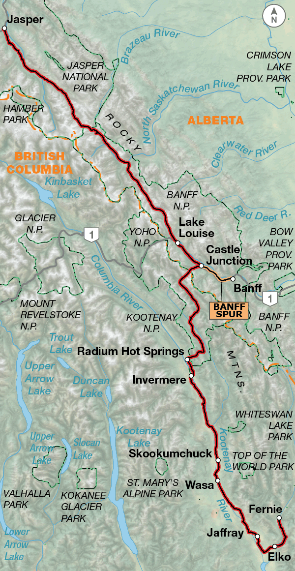
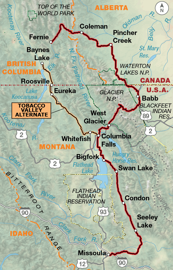
The route begins in Jasper, Alberta, a busy tourist center in the heart of Jasper National Park, one of the five Canadian Parks the route traverses. You will be amazed by the scenery: glacial lakes, dramatic waterfalls, piercingly steep mountains covered with glaciers, and a tremendous variety of wildlife; you will stop frequent just to marvel at the beauty. Be sure to ride cautiously among the tourists in recreational vehicles. As you head south, over several passes through the parks, take the time to go to Lake Louise and Banff, which both offer a wide variety of tourist services and charm. After 230 miles of amazing vistas, you’ll leave Kootenay National Park and descend steeply into the town of Radium Hot Springs. Stop for an enjoyable soak in the soothing hot mineral pools. From Radium Hot Springs southward to Elko, the western side of the Rockies offers gentler cycling following the Columbia and Kootenay river systems. At Elko, the route turns east over the Continental Divide through a series of small mining communities. You’ll see the prairies begin on the eastern slope and traverse the foothills through Waterton Lakes National Park, another mountain jewel of the Canadian Parks. The border crossing into the United States at Chief Mountain is only open from mid-May through mid-September, and then you’re in Glacier National Park in Montana, crossing the Divide back to the western side on the spectacular Going-to-the-Sun Road. You’ll find no major climbs or descents after leaving the park, and the route mainly follows river valleys bracketed by mountain ranges all the way into Missoula.
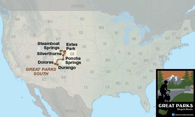
Great Parks South
This route, entirely in the Colorado Rocky Mountains, offers challenging biking, including riding on Trail Ridge Road, the highest continuous paved road in the continental United States, located in Rocky Mountain National Park. Eleven miles of it are above treeline.
The cyclist is rewarded by a continuous setting of dramatic mountain scenery, national forests, parks, monuments, and many climbs and descents over passes. Off-road mountain-biking opportunities abound at the various ski hills along the route, which offer singletrack riding on quiet forest trails, serviced by bustling tourist villages.
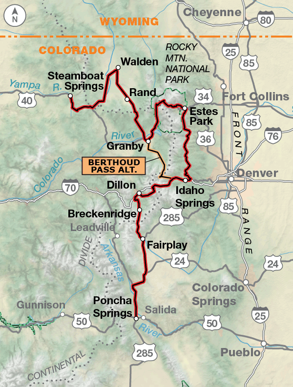
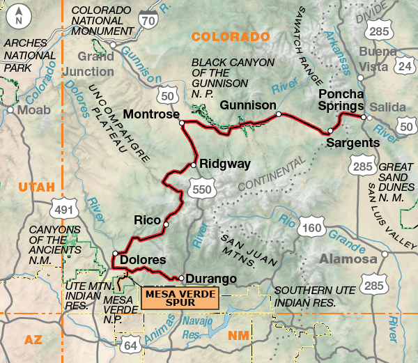
The route begins in northern Colorado in the ski town of Steamboat Springs. After a gut-busting climb out of Steamboat Springs to Rabbit Ears Pass and Muddy Pass, you’ll find open grazing land and national forest lands heading to Granby, near the southern entrance to Rocky Mountain National Park. Traffic can be heavy approaching the park and throughout the park, and you’ll spend many hours climbing and descending Trail Ridge Road. From Estes Park to Georgetown, this area is the playground for Denver, the surrounding communities on the Front Range and also much of the nation. Communities from Keystone to Breckenridge have become major year-round tourist destinations, so be prepared for traffic and recreational vehicles. There is a very good paved trail system in Summit County. South of Fairplay, the route becomes rural and traverses the high, open land of South Park. After crossing Trout Creek Pass, the route drops into the Arkansas River Valley near Buena Vista. The western slope of the Colorado Rocky Mountains is old mining country, from Salida all the way into Durango. Around Dolores, the mountains give way to the dry, open Four Corners region, highlighted by Mesa Verde National Park. Durango is the southern terminus of the historic Durango and Silverton Narrow Gauge Railroad, the only remaining regularly scheduled narrow-gauge passenger train.
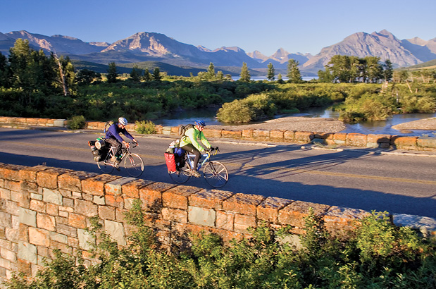
Photo by Chuck Haney
Great Parks North
The Great Parks North terrain is a series of climbs and descents over passes into various river valleys. In the southern part of the route, you’ll stay in the valleys and experience rolling terrain. The route crosses the Continental Divide three times.
Great Parks South
On Great Parks South, you will cross eleven mountain passes, and six of these will be over the Continental Divide. The highest point on the route is at 12,183 feet in Rocky Mountain National Park. The route follows a few river valleys, but for the most part you will be either climbing or descending.
Great Parks North - Main Route
Section
Distance
Elevation
Total Climb
Avg. Climb/mile
Total
741.0 miles
Minimum: 2,470 ft.Maximum:6,825 ft.
40,775 ft. south bound40,765 ft. north bound
55 ft. per mi. south bound55 ft. per mi. north bound
1
370.2 miles
Minimum: 2,470 ft.Maximum:6,825 ft.
21,055 ft. south bound21,015 ft. north bound
57 ft. per mi. south bound57 ft. per mi. north bound
2
370.8 miles
Minimum: 2,895 ft.Maximum:6,650 ft.
19,720 ft. south bound19,750 ft. north bound
53 ft. per mi. south bound53 ft. per mi. north bound
Great Parks South
Name
Section
Distance
Total Climb
Avg. Climb/mile
Total
695.0 miles
Minimum: 5,805 ft.Maximum:12,175 ft.
53,075 ft. south bound53,293 ft. north bound
76 ft. per mi. south bound77 ft. per mi. north bound
1
386.8 miles
Minimum: 6,700 ft.Maximum:12,175 ft.
30,930 ft. south bound30,065 ft. north bound
80 ft. per mi. south bound78 ft. per mi. north bound
2
305.5 miles
Minimum: 5,805 ft.Maximum:11,320 ft.
22,185 ft. south bound23,228 ft. north bound
73 ft. per mi. south bound76 ft. per mi. north bound
Great Parks North Alternates
Name
Section
Distance
Total Climb
Avg. Climb/mile
Banff Spur
1
19.0 miles
910 ft. south bound1,330 ft. north bound
48 ft. per mi. south bound70 ft. per mi. north bound
Gravel Alternate
1
20.9 miles
1,425 ft. south bound1,310 ft. north bound
68 ft. per mi. south bound63 ft. per mi. north bound
Tobacco Valley Alternate
2
100.0 miles
4,955 ft. north bound4,950 ft. north bound
50 ft. per mi. north bound50 ft. per mi. north bound
Great Parks South Alternates
Name
Section
Distance
Total Climb
Avg. Climb/mile
Berthoud Pass Alternate
1
47.0 miles
4,095 ft. south bound3,795 ft. north bound
87 ft. per mi. south bound81 ft. per mi. north bound
Mesa Verde Spur
2
52.3 miles
5,890 ft. clockwise ft. clockwise
113 ft. per mi. clockwise ft. per mi. clockwise
Great Parks North
This route should be ridden from early summer to mid-fall (typically June to September). Going-to-the-Sun Road in Glacier National Park is usually closed until early to mid June and has limited hours for cyclists which is noted on the map. Snow can occur at any time during the summer in the Rocky Mountains so be prepared with cold weather gear. Due to changing local conditions, it is difficult to predict any major wind patterns.
Jasper can be reached by rail service from Edmonton, Alberta. Along the entire length of the route, small towns at regular intervals provide ample services, but plan ahead due to crowded tourist conditions, especially in the Canadian Park System and in Glacier National Park. Reservations at both hostels and campgrounds are recommended. For off-road bicycling and primitive camping, a water purifier is necessary.
Great Parks South
This route can be ridden from early summer to mid-fall (typically June to September). Trail Ridge Road is closed between October and June. Snow can occur at any time during the summer in the Rocky Mountains. Altitude sickness can slow you down, so preparation for the high altitude is important. Arriving a few days before your trip begins is a good way to acclimate.
In Colorado, high-altitude services from campground water to grocery stores can shut down early in the autumn depending on weather. A water purifier is recommended. Due to high levels of tourist activity in the summer, reservations for accommodations and campgrounds are recommended.
Some campgrounds will charge a cyclist traveling alone less if they have hiker/biker sites, but often they will charge the price of a regular tent site, and that can easily be $10-$20/night. The maps list churches that have opened their doors to cyclists, but they aren’t all that closely spaced. If you’re friendly and ask around, you can often get yourself invited to camp in a yard. In the U.S. our routes go through national forests (moreso in the west) and you are allowed to camp anywhere on national forest land as long as you “pack it in, pack it out.” Many city parks are free to camp in.
You may also wish to sign up with Warmshowers, a reciprocal hospitality site for bicycle travelers, for other overnight options.
Route Highlights
Great Parks Highlights
Jasper National Park, Great Parks North Section 1
Banff National Park, Great Parks North Section 1
Kootenay National Park, Great Parks North Section 1
Waterton Lakes National Park, Great Parks North Section 2
Going-to-the-Sun Rd., Great Parks North Section 2
Glacier National Park, Great Parks North Section 2
Rocky Mountain National Park, Great Parks South Section 1
Black Canyon of the Gunnison National Park, Great Parks South Section 2
Telluride, Colorado, Great Parks South Section 2
Mesa Verde National Park, Mesa Verde Spur, Great Parks South Section 2
Connect and share photos with other riders on Instagram: #acaGrParksN and #acaGrParksS
RIDING CONDITIONS
Roads in Canada are generally good to excellent. There are wide shoulders along most of the highways on the route, but don’t let it lull you into a careless state of mind. Slow-moving cars and RVs often drive on this shoulder to let the faster traffic pass. Near towns, important intersections, and turn-outs, the wide shoulder becomes a second driving lane. Use extra caution in these places.
With the exception of the National Park roads, traffic tends to be light to moderate. Near and in any of the parks cyclists will have to contend with higher traffic levels and RV drivers who are inexperienced. To avoid heavy traffic, try to ride early in the day and make yourself and your bike visible with bright clothing or a reflective triangle. During the summer, traffic from Jasper southward to Banff is extremely heavy. Wildlife is abundant; ride slowly and cautiously past any animals so you do not spook them.
Throughout the entire Park system, you will be either climbing or descending. The route finally levels out when it reaches the Columbia and Kootenay river valleys.
South of Jasper, the route uses the quieter and more scenic PR 93A. This is a narrow road with a deteriorating surface which rejoins the wider PR 93 at Athabasca Falls.
Between Sunwapta Pass and Lake Louise, dangerous cracks and large culverts interrupt the road and shoulder surface. Orange warning signs are posted at the worst of them, but be prepared because many aren’t signed. Though it may be difficult, go slowly when descending.
At Castle Junction the 19-mile Banff Spur heads southeastward to Banff. Most of this is on PR 1A, the less traveled, but still busy narrow and winding old highway. The Banff Legacy Trail and several roads lead into town. This trail also continues east to Canmore.
During the summer months there is a shuttle service that will transport passengers with bicycles between the Jasper and Banff hostels. Contact SunDog Tours at 780-852-4056 or 888-786-3641, or www.sundogtours.com.
Between Castle Junction and Radium Hot Springs, stock up on food and water before riding the nearly serviceless 65.2-mile stretch through Kootenay National Park.
West Side Rd. south of Invermere, Wardner-Fort Steele Rd. and Jaffray-Baynes Lake Rd. are all lightly trafficked two-lane roads with no shoulders. These parallel roads avoid the more heavily traveled PR 93/95.
A quiet 20.9-mile Gravel Alternate between Elko and Fernie offers respite from the high traffic levels on PR 3. This is also a section of the Elk Valley Trail. A brochure, distributed by the Fernie Trails Alliance, can be found at: advcy.link/FTA.
CLIMATE
The most reliable characteristic of the Canadian Rocky Mountains weather is its variability. The climate can vary from one valley to the next, and indeed within very short distances. Local climatic conditions are affected by altitude, proximity to large lakes, wind flows through the valleys, and the rain shadow effect of the high mountains. It is always best to be prepared for sudden changes in the weather.
Updated: Nov 12, 2019
RIDING CONDITIONS
In Canada you’ll find good to excellent roads with moderate shoulders. Traffic is usually light to moderate, although there is some truck traffic, particularly in the coal-mining area near Fernie and Sparwood. The Elk Valley Trail is part of the Great Divide Mountain Bike Route, and is not recommended for road bikes because of its mixed surfaces and steep climbs. Around Crowsnest Pass, recreational traffic will be heavy on weekends.
The border crossing on Chief Mountain International Highway is closed from mid-September through mid-May. South of the border, there is a stretch of steep hills heading toward Babb.
Snow closes Going-to-the-Sun Rd. in Glacier National Park between Saint Mary and West Glacier from about mid-September to mid-June. For current road status, see advcy.link/glacierroadstatus. The road gets very heavy traffic during the summer. It is advisable to ride early in the day and avoid weekend travel. Maximize your visibility with a safety vest, triangle, or flag. The west side of Logan Pass is steep, narrow and has many blind corners, and there is a tunnel and drainage grates. Bicycle restrictions are in effect from June 15th through Labor Day. For northbound (uphill) cyclists ONLY, the section of the road from Logan Creek to Logan Pass is prohibited between 11 A.M. and 4 P.M. Between Sprague Creek Campground and Apgar Campground bicycles are prohibited between 11 A.M. to 4 P.M. IN BOTH DIRECTIONS.
Roads in Montana usually range from fair to good. Instead of using busy U.S. 2 between West Glacier and Columbia Falls, the route follows bike paths and side roads with 2.7 miles of gravel which becomes more washboarded as summer progresses. We highly recommend you use this route to avoid a dangerously narrow, curvy, shoulderless section of U.S. 2 east of Columbia Falls. Ride cautiously on shoulderless SR 35 south of Bigfork. Traffic increases around most towns, and you’ll encounter logging trucks along SR 83 and SR 200. Boy Scout Rd. offers a respite from SR 83 traffic but lacks services. South of Seeley Lake, SR 83 becomes narrow and curvy, especially near Salmon Lake. On SR 200, shoulders are wide but beware of the deep rumble strips.
The Tobacco Valley Alternate, which bypasses Glacier and Waterton Lakes National Parks, is 100 miles in length. South of the border, U.S. 93 carries some high speed traffic and trucks, so the route uses parallel smaller roads wherever possible. To complete a loop to Fernie, BC, you will need section 1 of the Great Parks North Route.
CLIMATE
Perhaps the most influential aspect of the northern Rocky Moun-tains is the prevailing westerly winds. These winds bring moist Pacific air from the ocean, and as this moist air is forced up over the mountain peaks, particularly the mountains of the Continental Divide, it cools. As the air is pushed up the temperature lowers, and this causes the moisture in the air to condense and precipitate. When the air descends on the downwind side of the mountains, it warms and stops precipitating. On occasion the wind comes from the east, pushing continental air up over the mountains. In this case, the normal situation is reversed, and precipitation is deposited on the Front Ranges. This upslope weather generally happens in the early summer.
Updated: Nov 12, 2019
RIDING CONDITIONS
Colorado is in the process of installing rumble strips on highways that have been resurfaced, so ride carefully along these roads.
This route is characterized by following river valleys and climbing over mountain passes at high altitudes. It is a strenuous route.
Steamboat Springs is a busy tourist town, as are many of the towns in this section. The traffic on U.S. 40 will diminish the farther away you go from town. The shoulder varies in width from none to six feet. SR 14 and SR 125 over Willow Creek Pass are narrow but lightly traveled.
U.S. 34 heading into and out of Rocky Mountain National Park has high levels of tourist traffic. Near and in any national park cyclists will have to contend with higher traffic levels and RV drivers who are inexperienced. To avoid heavy traffic try to ride early in the day and make yourself and your bike visible. In the Park, Trail Ridge Rd. is one of the great alpine roads in the U.S. Its winding course takes you 12,183′ above sea level through the high alpine tundra ecosystem.
If you choose the Berthoud Pass Alternate you’ll miss Rocky Mountain National Park. But the Alternate is 99 miles shorter than the main route and uses U.S. 40.
Between Central City and I-70 the privately owned Central City Parkway is a steady 7-8% grade for 8 miles. It has good shoulders.
The route parallels I-70 on frontage roads until the climb over Loveland Pass. Then it descends to the resort towns of Keystone, Dillon, Frisco and Breckenridge where the route follows side roads and various bike paths. Recreational facilities here attract many weekenders and vacationers from the more densely populated eastern slope of the Rockies. Traffic can be heavy, but the route mostly avoids this traffic by using bike paths through the area. See advcy.link/summitcomap for a map of Summit County bike paths.
SR 9 up and over Hoosier Pass is narrow and carries heavy traffic during the summer. Extra caution is advised. It is a moderately difficult climb. Riders gain 1,500′ within 10 miles in order to reach the top of the pass.
After Hoosier Pass the country spreads out and traffic thins. Be careful on U.S. 285 north of Trout Creek Pass due to narrow shoulders, rumble strips and a higher traffic volume. South of the pass there are moderate shoulders to Poncha Springs.
NOTE: After October 1st, many private and U.S.F.S. campgrounds close for the winter or have no water available. Call ahead to verify conditions if you are traveling after this date.
CLIMATE
Most of Colorado has a cool and invigorating climate that could be termed a highland or mountain climate of a continental location. Humidity is generally quite low: this favors rapid evaporation and a relatively comfortable feeling even on hot days. The thin atmosphere allows greater penetration of solar radiation and results in pleasant daytime conditions.
The climates of local areas are profoundly affected by differences in elevation, and to a lesser degree, by the orientation of mountain ranges and valleys with respect to general air movements. Prevailing air currents reach Colorado from westerly directions.
Updated: Sep 24, 2018
RIDING CONDITIONS
Heading west from Poncha Springs, the route uses U.S. 50 until reaching Montrose. The highway shoulder’s widths change and traffic levels increase around the Curecanti National Recreation Area and within towns. Be careful when crossing the rumble strips located on the newer stretches of the highway.
All of the highways on this section are two-lane roads with shoulders varying from none to 10-feet wide.
After leaving the wide Uncompahgre River valley and Ridgway, the route heads back into the foothills of the higher mountains and over the Dallas Divide. Many of the passes along the route have climbing lanes for slower-moving traffic.
Ride carefully along the San Miguel River between Placerville and the turn-off to Telluride. The highway is continuously winding with short sight lines, and has high levels of summer traffic. If you choose, there is a bike path along the highway to go into historic Telluride.
Traffic will increase in the towns of Cortez and Mancos. U.S. 160 has a wide shoulder as you head into Durango, the end of the route.
Near and in any national parks cyclists will have to contend with higher traffic levels and RV drivers who are inexperienced. To avoid heavy traffic try to ride early in the day and make yourself and your bike visible.
Mesa Verde National Park is known as a World Class Park and an out and back spur is shown. However it’s not particularly bicycle-friendly, especially during the summer tourist season, because the roads have no shoulders. To visit the major ruins will require several thousand feet of climbing and descending. One option for viewing the ruins is to camp at Morefield Campground and reserve a spot on one of the bus tours. Go to this link for cycling restrictions within the park: www.nps.gov/meve/planyourvisit/gettingaround.htm.
NOTE: After October first, many private and U.S.F.S. campgrounds close for the winter or have no water available. Call ahead to verify conditions if you are travelling after this date.
CLIMATE
The rugged topography of western Colorado causes large variations in climate within short distances, and few climatic generalizations apply to the whole area. Summer in the mountains is a cool and refreshing season. At typical mountain stations the average July temperature is in the neighborhood of 60 degrees F. The highest temperatures are usually in the 70’s and 80’s, but may reach 95 degrees F. Above 7,000 feet, the nights are quite cool throughout the summer, while bright sunshine makes the days comfortably warm.
Updated: Dec 19, 2017
Updates to Recently Released Maps
If you are planning a bike tour, be sure to get the most recent map updates and corrections for your route by selecting the route, and the appropriate section(s), from the drop-down menu below.
Over time maps become less useful because things change. Every year Adventure Cycling’s Routes and Mapping Department create map updates and corrections for every map in the Adventure Cycling Route Network, which now totals 52,047 miles. With the help of touring cyclists like you, we receive updates on routing, services, camping, and contact information. Until we can reprint the map with the new information, we verify the suggested changes and publish corrections and updates here on our website.
PLEASE NOTE: Covid has been particularly hard on the small businesses along our routes. While we do our best to keep the maps and these online updates current, you may encounter more closed businesses and longer stretches with limited or no services.
Refer to these updates for the most current information we have and submit reports of changes to the Route Feedback Form for the cyclists coming after you.
NOTE: Map updates and corrections only pertain to long term changes and updates. For short term road closures, please see the Adventure Cycling’s Routes Temporary Road Closures discussion in our Forums.
The BC number and year on your map's cover should match the BC number and year listed here.
Section Information
(Jan 2020) TOTAL MILEAGE: Total mileage for the section should be 370.2 (total of the main panel mileages).
(Jan 2020) Due to planned construction to replace and upgrade services, Castle Mountain Campground is expected to close for the season on July 2, 2020.
(Jan 2020) In Banff, The Tune Shop is now at 116 Eagle Crescent.
(Jan 2020) In Banff, Tunnel Mountain Village I Campground is open Jun. – early Oct.
(Jan 2020) In Banff, the toll free number for Mount Royal Hotel is 877-862-2623.
Updated: May 2022
Map 01
(Sep 2019) In Jasper, a new bike shop is The Bench Bike Shop, 606 Patricia St., 780-852-7768.
(Dec 2019) In Jasper, RCMP phone number is now 780-852-4848.
(Dec 2019) In Jasper, Freewheel Cycle Jasper is closed.
(Dec 2019) In Jasper, Whistlers Inn 2nd phone number should be 800-282-9919.
(Jan 2020) In Jasper, Jasper-Yellowhead Museum is located at 400 Bonhomme St.
(Jan 2020) In Jasper, the phone for Jasper Downtown Hostel is 780-852-2000.
(Jan 2020) In Jasper National Park, the number for general information is 780-852-6176 and the Warden is 780-852-6155.
Updated: Jan 2020
Map 02
(Jun 2023) Jonas Creek Campground has hiker/biker sites.
Updated: Jun 2023
Map 03
(Dec 2019) Glacier View Inn is now Glacier View Lodge, and has a phone number of 888-770-6914.
(Jan 2020) In Banff National Park, the number for camping reservations is 877-737-3783 and the Warden is 403-762-1470.
Updated: Jan 2020
Map 06
(Dec 2019) In Lake Louise, the general phone number for Lake Louise Alpine Centre is 403-522-2201. The 2 numbers listed are reservations numbers.
Updated: Jan 2020
Map 07
(Jan 2020) Due to planned construction to replace and upgrade services, Castle Mountain Campground is expected to close for the season on July 2, 2020.
Updated: Jan 2020
Map 09
(Dec 2019) In Invermere, DR Sports appears is closed.
(Dec 2019) In Invermere, Elemental Cycle (bike shop) is located at 905 7th Ave. #102, 778-526-5111.
(Dec 2019) In Invermere, Bicycle Works is now a mobile service. Same phone number. No physical location.
(Dec 2019) In Invermere, Super 8 is now The Kanata. Same address and phone number.
(Dec 2019) At Spruce Grove RV Park and Campground there is no R.
(Jan 2020) In Fairmont Hot Springs, phone numbers for the Fairmont Hot Springs resort are 250-345-6070 or 800-663-4979.
Updated: Jan 2020
Map 10
(Jan 2020) In Canal Flats, another phone number for The Flats RV and Campground is 250-270-0838.
(Sep 2019) In Skookumchuck, the CS is closed.
Updated: Jan 2020
Map 11
(Jan 2020) In Wasa, the phone number for Wasa Lake Provincial Park is 250-422-3003.
Updated: Jan 2020
Map 12
(Jan 2020) Emery’s Mountain View B&B is closed.
Updated: Jan 2020
Map 13
(Aug 2019) The number for Kikomun Creek Provincial Park should be 250-422-3003.
(Aug 2019) In Elko, there is not a post office.
(Aug 2019) In Fernie, Snow Valley Motel is now called Snow Valley Lodging and has a new number: 877-696-7669.
(Jan 2020) In Fernie, phone numbers for The Guide’s Hut bike shop are 250-423-3650, 888-843-4885.
Updated: Jan 2020
You are one of our best resources for keeping our maps up-to-date. Please notify us of any errors you find. Contact us at: Routes and Mapping Dept., Adventure Cycling Association, PO Box 8308, Missoula, MT 59807, 800-755-2453, email cartography@adventurecycling.org.
The BC number and year on your map's cover should match the BC number and year listed here.
Section Information
(Jul 2022) The Chief Mountain border crossing is open for the 2023 season from May 15 – Sept. 30. Port of entry hours are May 15 – May 31: 9:00 a.m. to 6:00 p.m.; June 1 – September 4: 7:00 a.m. to 10:00 p.m.; September 5 – September 30: 9:00 a.m. to 6:00 p.m. The border crossing is closed from October 1 – May 14.
(Oct 2022) Take caution while riding on US 93 between Eureka and Whitefish MT. There have been multiple reports of high speed, high traffic and variable shoulder conditions.
Updated: May 2023
Map A
(Jul 2022) In Eureka, the Eureka Branch Library phone number should be 406-297-2613.
(Jul 2022) In Roosville, there is also a bar with food.
Updated: Jul 2022
Map B
(Jul 2022) In Fortine, there is a convenience store 0.7 miles south on US 93.
Updated: Jul 2022
Map C
(Jul 2022) In Whitefish, the Stumptown Inn is now Apres Whitefish.
(Jul 2022) In Whitefish, Boedie Cycles has moved to 107 Fir Ave.
(Jun 2022) In Whitefish, the Chalet Motel is located at 6430 US 93, 406-862-5581.
(Jun 2022) In Whitefish, the Downtowner Inn is closed.
(Jan 2020) In Whitefish, Boedie Cycles is open May-Sept., closed Sun. – Mon.
Updated: Jul 2022
Map 14
(Aug 2019) In Fernie, Snow Valley Motel is now called Snow Valley Lodging and has a new number: 877-696-7669.
(Jan 2020) In Fernie, phone numbers for The Guide’s Hut bike shop are 250-423-3650 and 888-843-4885.
Updated: Jan 2020
Map 18
(Aug 2022) South of Babb, camping is available at Duck Lake Campground, off route 4.6 mi. E. on Duck Lake Rd./CR 464, then 1 mi. N. on S. Shore Rd., 406-338-4557.
(Jun 2018) In Babb, the phone for the Leaning Tree Campground and Cafe should be 406-845-4200.
(Oct 2019) In Babb, Thronson’s Motel has a CS and R.
(Apr 2023) Glacier National Park has instituted a ticketed entry system for the Going-to-the-Sun Road corridor between the park’s West and St. Mary Entrances from May 26 to September 10, 2023. The Park’s website has detailed information about this. It states that “Visitors arriving on foot or bicycle do not require a day-use entry reservation ticket.” Anyone who is touring will be able to ride Going-to-the-Sun Road, as long as they follow the existing restrictions that are already noted on our Great Parks North map.
Updated: Apr 2023
Map 19
(Sep 2019) In West Glacier, Glacier Highland Resort is open May – Sept.
(Apr 2021) Glacier National Park has instituted a ticketed entry system for the Going-to-the-Sun Road corridor between the park’s West and St. Mary Entrances from May 28 to September 6, 2021. The Park’s website has detailed information about this. It states that “Visitors arriving on foot or bicycle do not require a day-use entry reservation ticket.” Anyone who is touring will be able to ride Going-to-the-Sun Road, as long as they follow the existing restrictions that are already noted on our Great Parks North map.
Updated: Mar 2021
Map 20
(Jul 2022) (June 2023) Eastbound, after turn C, the first mile on US 93 has no shoulders, blind corners, short steep climbs and lots of traffic. Ride cautiously and carefully and wear bright colors. Westbound, be careful when leaving Whitefish on the 1 mi. section of US 93 before turn C.
(July 2022) In Columbia Falls, the Glacier Travel Inn is now called Wonderstone, the phone number and location remain the same.
(Jul 2022) In Whitefish, Mountain View RV Park no longer offers tent camping.
(Jun 2021) In Columbia Falls, Over the Mountains Bikes is closed.
(Jul 2021) Outside of Columbia Falls, Montana Bike Hostel has hostel beds and camping available at 3384 Trumble Creek Rd., (520) 797-5501. They are open late June – early Sept. Call to see if available outside this time.
Updated: Jun 2023
Map 21
(Jun 2023) In Ferndale, County Line Coffee offers cyclists’ only camping at 30673 SR 209, (406) 210-5079. There are currently no restrooms, but there should be an outhouse soon.
(Jul 2022) In Swan Lake, the Swan Lake Campground phone number is now 406-752-7924.
(Jul 2022) In Ferndale, the Candlewyck Inn is no longer in business.
(Jul 2022) In Bigfork, Timbers motel phone number is now 406-837-6200.
(Sep 2019) In Bigfork, Wayfarers State Park is open Apr. – Oct.
(Jun 2021) In Bigfork, Over the Mountain Bikes is located at 160 SR 209, (406) 407-3896.
(Jul 2021) In Swan Lake, the Swan Lake Trading Post and Campground is closed for the 2021 season due to renovations.
Updated: Jun 2023
Map 22
(Dec 2022) Veterans Camp Ponderosa is located 12.6 mi. S. of Swan Lake, 100 yards E. on Goat Creek Rd. to entrance, (406) 754-2552.
Updated: Dec 2022
Map 23
(Jul 2022) South of Condon, the Holland Lake Campground phone number is now 406-752-7924. There are regularly held events (weddings, etc.) and in those cases the restaurant is closed and service is only available to guests. For non-guests, they only serve drinks and sell candy bars.
Updated: Jul 2023
Map 24
(Apr 2021) In Seeley Lake, the Wilderness Gateway Inn and the Seeley Lake Motor Lodge are closed.
(Jun 2021) In Seeley Lake, indoor lodging can be found at Tamaracks Resort, located from town, off route 2.3 mi. N. at 3481 SR 83, 406-677-2433; or at Double Arrow Lodge, located from town, off route 2.4 mi. S. on SR 83, then 0.5 mi. NE on Lodge Way, 406-677-2777.
(Jan 2021) The Lubrecht Experimental Forest no longer allows camping. Reservations are required for the cabins.
(May 2023) Reconstruction work has begun on SR 83 for approximately 4 miles along the east side of Salmon Lake which is located south of Seeley Lake. Work hours will be primarily 6 days/week from 7 AM – 7 PM. There will be temporary lane closures and delays, and shoulders will be limited. The contractor hasn’t made any accommodations for bicyclists, so we recommend asking a pickup truck driver if you can get a ride by placing your bike in the pickup bed. The work will continue into the spring of 2024.
Updated: May 2023
Map 25
(Mar 2023) In Missoula, we’ve received negative reviews of Red Lion Inn & Suites. Other hotel options are: Holiday Inn Missoula Downtown, 200 S. Pattee St., 406-721-8550 and Days Inn, 744 E. Broadway, 406-519-4032.
(Jan 2021) In Missoula, we have received bad reviews about Bel Aire Motel.
(June 2021) In Missoula, it is highly recommended that you call ahead and make reservations if staying at the Missoula KOA.
Updated: Mar 2023
You are one of our best resources for keeping our maps up-to-date. Please notify us of any errors you find. Contact us at: Routes and Mapping Dept., Adventure Cycling Association, PO Box 8308, Missoula, MT 59807, 800-755-2453, email cartography@adventurecycling.org.
The BC number and year on your map's cover should match the BC number and year listed here.
Berthoud Pass Alternate
(Jan 2021) In Granby, Full Circle Cyclery has moved to 61000 US 40, located inside Power World Sports, and the phone is 970-887-9337.
(Jul 2021) In Granby, The Headwaters Hostel (pvt.) is located at 217 W. agate Ave., 970-425-6847. Camping is allowed with access to the hostel facilities.
Updated: Jul 2021
Map 01
(Aug 2022) In Steamboat Springs, Ski Haus’s bike shop phone number is now (970) 879-0424.
(Jan 2021) In Steamboat Springs, another lodging option is Quality Inn & Suites, located at 1055 Walton Creek Rd., 970-879-6669.
Updated: Aug 2022
Map 03
(Sep 2022) Denver Creek Campground is indefinitely closed due to wildfire damage.
Updated: Sep 2022
Map 07
(Jul 2019) Black Hawk has a required, signed bike route through town, the route shown on the map is incorrect and illegal. The correct route may be found here: ridewithgps.com/routes/30649298
(Jan 2021) In Idaho Springs, A Culture of Speed bike shop is closed.
Updated: Jan 2021
Map 08
(Aug 2022) In Silverthorne, the North Branch Library has moved to 325 Blue River Pkwy.
(Jul 2022) In Silverthorne, The PAD, offering hostel-style rooms, is located at 491 Rainbow Dr., 970-445-7767.
(Jul 2022) Near Breckenridge, Wayside Inn is closed.
Updated: Aug 2022
Map 09
(Aug 2022) In Breckenridge, The Village at Breckenridge phone number is now (970) 453-4334
Updated: Aug 2022
Map 11
(Aug 2023) In Salida, the Wilderness Expeditions RV Park and Campground’s name has changed to Riverside RV Park.
(May 2022) Near Salida, Hayduke’s Hideout offers cyclists only camping with a kitchen. It’s located at 8875 CR 126, 650-676-0614 or 801-598-9783.
(Dec 2018) Salida East Recreation Site (BLM/Colorado Parks & Wildlife) has primitive camping located 3.1 mi. S. of Salida, 719-539-7289.
Updated: Aug 2023
You are one of our best resources for keeping our maps up-to-date. Please notify us of any errors you find. Contact us at: Routes and Mapping Dept., Adventure Cycling Association, PO Box 8308, Missoula, MT 59807, 800-755-2453, email cartography@adventurecycling.org.
The BC number and year on your map's cover should match the BC number and year listed here.
Section Information
(Mar 2021) Riding Conditions: A 4-mile stretch of US 50 between Sapinero and Cimarron (map 15) will be undergoing major construction until November 2022. There will be significant traffic impacts. During the weekdays, the roadway will be open for single-lane, alternating traffic. Parts of the roadway will be reduced to dirt and gravel. Expect long wait times, and note that the area of construction is in a remote area with no nearby services. The construction zone will be fully open to two-way traffic on the weekends (5:30 PM Friday to 8:30 AM Monday), although traffic will be higher. SR 92 (the vehicle detour) is not recommended as a safe biking alternative, and there are no other detours around the construction zone less than 100 miles. We recommend asking a motorist for a ride through the construction zone, or asking the project team to help you find a way across. We also recommend contacting the project team in advance. See www.us50info.com and https://www.codot.gov/news/2021/april-2021/us50-little-blue-creek-detours for contact information and detailed information about the project.
Updated: May 2022
Mesa Verde Spur
(Nov 2016) The Museum Loop Rd. arrow should be reversed.
(Nov 2016) The POI North Rim Overlook is now called Geologic Overlook.
(Nov 2016) The POI Far View Visitor Center has closed. It has been replaced by the Mesa Verde Visitor and Research Center which is just past the entrance of the park.
Updated: Nov 2016
Map 12
(Aug 2023) In Salida, the Wilderness Expeditions RV Park and Campground’s name has changed to Riverside RV Park.
(Apr 2018) In Salida, the hospital phone number is 719-530-2200.
(Apr 2018) In Salida, the Aspen Leaf Lodge is now called the Amigo Motor Lodge, same address and phone but the toll-free number no longer works.
(Nov 2016) In Salida, Salida Bike Co. is located at 148 N. F St., 719-539-4466.
(Nov 2016) In Salida, Wilderness Expeditions Campground and Lodge has a new phone number: 719-539-4888, and it is off route 3 mi. E., not W.
(Nov 2016) In Salida, the Salida Hostel (pvt.) is located at 225 W. SR 291, some bike tools available, 719-530-1116.
(Nov 2016) In Salida, the Best Western Colorado Lodge is now called the Great Western Colorado Lodge.
(Jan 2020) In Poncha Springs,
Heart of the Rockies Campground is now Salida/Mt. Shavano KOA. Local phone and address are the same. 800 number no longer applies. Cabins also.
(Nov 2016) In Maysville, River Suites at Monarch Shadows is now called River Suites Luxury Cabins & Villas and has a new toll free phone number: 866-539-6953.
(Sep 2018) The population of Poncha Springs i 737, not 466.
(Sep 2018) In Poncha Springs, Rocky Mountain Lodge is located at 10036 US 50, 719-539-4143.
Updated: Aug 2023
Map 13
(Nov 2022) In Colorado, the Saguache County Sheriff’s office phone number is (719) 655-2240.
Updated: Nov 2022
Map 14
(Nov 2022) In Gunnison, the Ann Zugelder Libraray is now the Gunnison Public Library and has relocated to 1 Quartz St.
(Oct 2015) In Gunnison, The Seasons Inn Motel is offering reduced room rates for self-supported touring cyclists. It’s located at 412 E. Tomichi Ave., 970-641-0700.
(Nov 2016) In Gunnison, the Super 8 is now an Econo Lodge.
(Nov 2016)In Gunnison, the Swiss Inn is now called the Sherpa Motel, with a new phone number: 970-641-3519.
Updated: Nov 2022
Map 15
(Jul 2021) In Sapinero, the Village Store and Campground no longer has a convenience store and is now the Sapinero Village Campground. It has a new phone number: (970) 641-3949
(May 2017) In Cimarron, the restaurant is closed and the grocery selection is very limited.
(Jan 2020)
In Cimarron, there is an R and a G.
Updated: Jul 2021
Map 16
(Nov 2016) In Montrose, Cyclists Only Lodging with Scott and Jenny Shine is no longer available.
(Nov 2016) The POI Montrose County Historical Museum has moved to 21 N. Rio Grande Ave.
Updated: Nov 2016
Map 17
(Nov 2016) In Ridgway, Ridgway Outdoor Experience is located at 153 N. US 550 (incorrect address).
(Nov 2017) In Ridgway, Ridgway Wrench Bike Shop is located at 380 Sherman St. #3, 970-318-0799.
(Nov 2017) In Ridgway, Peak to Peak Bicycles is closed.
(Jan 2020)
In Ridgeway, Adobe Inn is located at 651 Liddell Dr.
Updated: Jan 2020
Map 18
(Aug 2022) Near Placerville, camping is available at Caddis Flats Campground, off route 2.3 mi. W. of town on SR 145, free, no water, first-come first-served, 970-240-5300.
(Jun 2021) The Angler Inn is now The Bivvi Hostel Telluride, 22332 SR 145, (970) 797-3404.
(Nov 2016) In Telluride, the POI San Miguel County Historical Society Museum is now called Telluride Historical Museum. The correct address is 201 W. Gregory Ave.
Updated: Aug 2022
Map 19
(Mar 2019) In Rico, the Mineshaft Inn, Hotel and Hostel is now called the Rico Mine Shaft Inn B&B, and has a new phone number: 970-967-4996.
(Jan 2020)
In Rico, the Rico Hotel Mountain Lodge is closed.
(Jan 2020)
In Rico, the library is now open Mon. – Sat.
Updated: Jan 2020
Map 20
(Jun 2021) In Dolores, Lizardhead Cyclery is closed.
(Nov 2016) In Dolores, the POI Dolores Anasazi Heritage Center is actually called the Anasazi Heritage Center. Also, on the map panel, the POI is named the Dolores Heritage Center. This should also be Anasazi Heritage Center
Updated: Jun 2021
Map 21
(Nov 2016) In Cortez, the Budget Host Inn is now called the Retro Inn at Mesa Verde.
(Nov 2016) In Mancos, the Old Mancos Inn is now called the Mancos Inn & Hostel with a new phone number: 970-533-9164.
Updated: Nov 2016
Map 22
(Nov 2016) In Hersperus, there is also a restaurant.
Updated: Nov 2016
You are one of our best resources for keeping our maps up-to-date. Please notify us of any errors you find. Contact us at: Routes and Mapping Dept., Adventure Cycling Association, PO Box 8308, Missoula, MT 59807, 800-755-2453, email cartography@adventurecycling.org.